


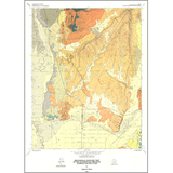
Provisional geologic map of the Gunnison quadrangle, Sanpete County, Utah (M-139)
By: S. R. Mattox
Approximately 17,180 feet of Middle Jurassic to Holocene rocks underlie the Gunnison quadrangle: 1,870 feet of these strata are exposed. The oldest sequence, the Middle Jurassic Arapien Shale, records sedimentation under shallow marine conditions in an inland sea. During the Late Cretaceous, coarse clastic material was shed eastward from the Sevier orogenic belt into the western foredeep of the foreland basin to produce the second sequence, the Indianola Group (undifferentiated). Erosion followed, producing a regional unconformity. Deposition of a third sequence followed, consisting of fluvial and lacustrine units. Surficial deposits include stream alluvium, colluvium, flood-plain, valley fill, alluvial fan, and mass movement, plus alluvial cover on pediments, eolian sand, and Lake Bonneville sediments.
Other Information:
Published: 1992
Pages: 11 p.
Plates: 2 pl.
Scale: 1:24,000
Location: Sanpete County
Media Type: Paper Map