


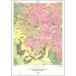
Provisional geologic and coal resources map for the Mt. Ellen quadrangle, Henry Mountains, Garfield County, Utah (M-90)
M90
In stock
1:24,000 Geologic Maps
$7.95
By: L. B. Morton
The Mt. Ellen quadrangle lies on the northern end of the Henry Mountains in high, dissected, locally folded and faulted mesas and steep alpine topography. The highest point, Mt. Ellen, stands 11,506 feet above sea level and is 19.9 miles southwest of Hanksville and 16.2 miles east of Capitol Reef National Park. More than 3,937 feet of Jurassic, Cretaceous, Tertiary, and Quaternary rocks are exposed in the Mt. Ellen quadrangle. Jurassic and Cretaceous rocks have been upwarped and locally altered by Tertiary diorite porphyry intrusions.
Other Information:
Published: 1986
Pages: 15 p.
Plates: 3 pl.
Scale: 1:24,000
Location: Garfield County
Media Type: Paper Map