


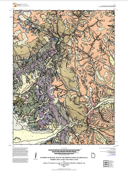
Interim Geologic Map of the Browns Hole Quadrangle, Weber and Cache Counties, Utah (OFR-760)
By: Zachary W. Anderson, Greg N. McDonald, Elizabeth A. Balgord, and W. Adolph Yonkee
The Browns Hole quadrangle is in Weber and Cache Counties of northern Utah and covers the eastern part of Ogden Valley, a rapidly developing area of the Wasatch Range. The Middle and South Forks of the Ogden River bisect the quadrangle and are important watersheds and recreational areas to the communities of Ogden Valley and the Wasatch Front. The towns of Huntsville and Eden are just west of the quadrangle and unincorporated communities with year-round residents are present throughout the area. A portion of Powder Mountain ski resort is present in the northwest corner. The quadrangle contains the Willard thrust, a major thrust fault that was active during the Cretaceous-Eocene Sevier orogeny. The Willard thrust places Neoproterozoic through Ordovician strata in the hanging wall over a fault-bounded block of Cambrian strata. Neoproterozoic strata comprise a succession of mostly clastic rocks that locally include a volcaniclastic sequence and basalt flows deposited during rifting of western North America and breakup of the supercontinent Rodinia. Cambrian strata in the hanging wall include a thick basal clastic sequence overlain by a thick sequence of interbedded limestone, shale, and dolomite. Footwall rocks of the Willard thrust include highly deformed Cambrian strata within a fault-bounded lozenge. The synorogenic Paleocene-Eocene Wasatch Formation unconformably overlies older rocks and was deposited over considerable paleotopography. The southwest part of the quadrangle is cut by a southwest-dipping normal fault system that bounds the east side of Ogden Valley. This fault is interpreted to have experienced an early phase of slip during late Eocene to Oligocene collapse of the Sevier belt and a younger phase of slip during Neogene Basin and Range extension. Lacustrine deposits and shorelines of Pleistocene-age Lake Bonneville are present in the lower elevations of the southwest corner. Pleistocene glacial deposits, present in the northwest corner, are likely related to the Pinedale glaciation. Numerous incised alluvial deposits and geomorphic surfaces are present along major drainages and record pre- and post-Lake Bonneville aggradational and degradational alluvial and colluvial sequences. Mass-movement deposits, including historically active landslides, are present throughout the quadrangle.
Published: 2024Pages: 13
Plates: 2